NYC's Past as a Model for Sustainable Planning
Posted by Glenn on February 11, 2007 - 5:06pm in The Oil Drum: Local
The good folks at NYC's PlaNYC 2030 sustainability office have just released a series of short powerpoint presentations establishing a baseline on a variety of sustainability metrics and their analysis on future trends.
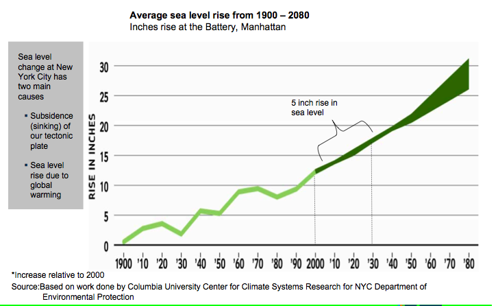
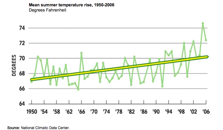
It paints a somewhat troubling picture of where we are now and where we are headed. Moreover, only some of this is within our own control. Because Global Warming is by definition not locally controlled, NYC might do everything in its power and still face major consequences of rising sea levels along with many other global port cities. In many senses though the point is not that NYC will be the decisive place where carbon reductions are found and the battle is won. Rather it's to show that NYC is doing more part in the fight against global warming and can continue to make great strides in reducing it's contribution. My hope is that NYC can be a shining light in the fight to reduce greenhouse gases, a showcase city proving that reductions in Greenhouse gases are not just possible, but economically efficient and increase quality of life. And when I say NYC, I'm really talking mostly about the infrastructure built in the 19th Century (dense, walkable, mixed use land use) and early 20th Century (extensive mass transit system complete with subways, regional train system and trolleys).
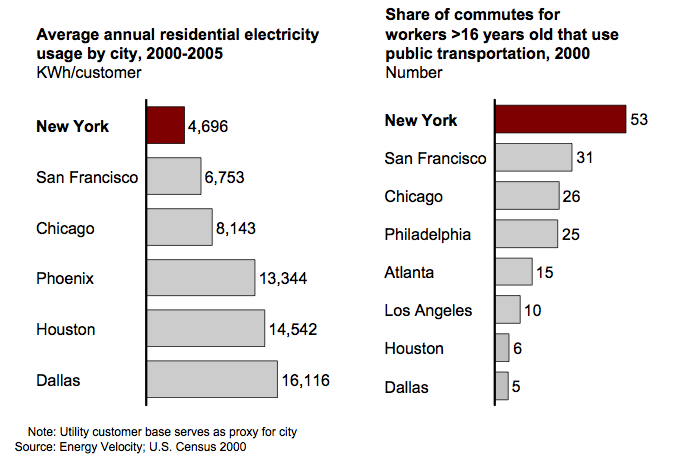
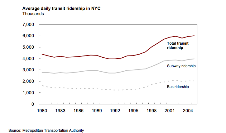
As I've discussed here many times before, NYC has two major head starts in building a more sustainable city than most others: Low per capita electricity usage and high mass transit ridership. Of course as a Northern city, it does not require as much air conditioning as Phoenix, Dallas or Houston. But NYC even outperforms similar northern cities like Chicago and San Francisco by a significant margin. Similarly, because NYC is very densely populated and retains much of it's pre-1950's subway infrastructure, it has a huge lead in non-automobile transportation options.
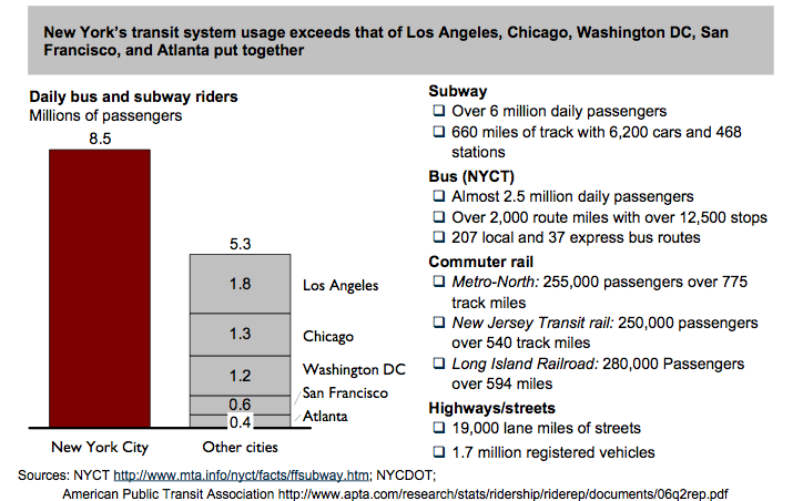
And because NYC is so much bigger than these cities NYC represents a much bigger share of the whole nation's mass transit usage.
Still, there is plenty of room for improvement for the city even on these two metrics. The city has seen great successes in reducing electrical demand in certain sectors (like replacing old appliances in NYCHA housing) and increasing mass transit ridership, but at the same time we face an onslaught of automobilies from across the region that pollute our densely populated residential areas.
Take NYC's bus transportation system as an example of some real good low hanging fruit. Despite having more daily passengers (2.5 million) than any other US city's total mass transit systems, it runs extremely slow comparitively due to NYC's issues with road congestion.
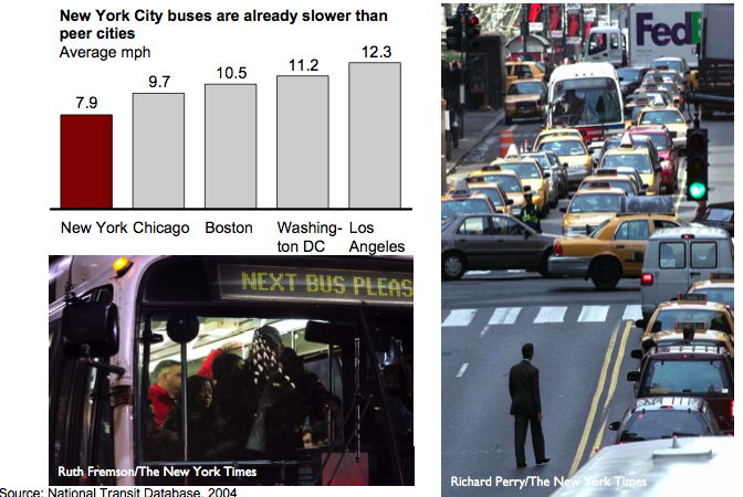
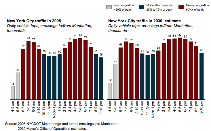
And the city is expecting that if left alone, the congestion is only going to get worse, to the point where rush hour might never end during the day. Furthermore, the city's 19,000 miles of roads are reaching full capacity for moving automobiles around
The city is looking at three major areas of reducing its green house gas emission footprint as shown in this slide at the end of the climate change deck:
For translation, I believe this is saying:
1. Conservation / efficiency on the demand side
2. Efficient and lower carbon emitting electricity production methods
3. Reducing the number of single occupant automobiles
It's great to see the city take on all of these initiatives and to establish the baseline of data from which we should make decisions and judge the success of the city's various programs. These goals would imply:
1. Critical financial incentives for new "green" buildings and retrofitting NYC's housing stock to be more energy efficient
2. Rebuilding many existing power plants to burn cleaner and use more combined cycle processes amd perhaps switching more of the power generation to low carbon renewables
3. Instituting a serious set of reforms to limit automobile usage like significantly higher parking fees, congestion pricing, less overall streetspace devoted to automobiles and encouragement of mass transit and cycling as legitimate transportation options.
At the same time the data on NYC's structural comparative advantage over other large cities highlights in many ways is how NYC and the rest of the country could do a lot by emulating what NYC already achieved (without really trying) on the back of its pre-1950s infrastructure.
What does that mean in today's world?
It means creating mass transit under the "if you build it, they will come" mindset instead of conducting a present day break-even analysis of the farebox. As the Mayor has often said in his PlaNYC speeches, "we built subways through farmlands".
It means rezoning transit hubs and corridors for greater density and mixed uses. This doesn't mean new megaprojects that over-emphasize one specific use (like perhaps a sports arena) that rely on government subsidies. Just plain old multi-story attached buildings with retail, residential, recreation, cultural and commercial office space within a walkable environment on top of a mass transit hub that limits automobile traffic. Desegregating zoning in pure residential areas would create retail destinations within walking or biking distance.
It also means encouraging smaller living units in the center of town for people to live instead of planning for sprawling McMansions. NYC simply ran out of space in many areas because of geographic limitations, but this can easily be created in other cities through open space zoning and limiting development on greenfield sites.
Is NYC perfect? Not by a long shot. As I've written here before many times, I think there is a lot that NYC can do to improve its sustainability. But it's leading the pack in many ways. As NYC and the rest of the country looks to the future, it should try to innovate ways of building a more sustainable future and in many cases that means considering NYC's pre-1950 land use planning and mass transit oriented development policies.
Personnel
Classic posts
Archives
- November 2008 (1)
- August 2008 (1)
- July 2008 (4)
- June 2008 (4)
- May 2008 (3)
- April 2008 (1)
- March 2008 (1)
- February 2008 (2)
- January 2008 (2)
- December 2007 (4)
- November 2007 (4)
- October 2007 (6)
The Oil Drum: New York City archives
- September 2007 (3)
- August 2007 (2)
- July 2007 (3)
- June 2007 (8)
- May 2007 (1)
- April 2007 (8)
- March 2007 (2)
- February 2007 (3)
- January 2007 (5)
- December 2006 (5)
- November 2006 (12)
- October 2006 (10)
- September 2006 (9)
- August 2006 (14)
- July 2006 (15)
- June 2006 (11)
- May 2006 (18)
- April 2006 (35)
- March 2006 (14)
- February 2006 (13)
- January 2006 (12)
- December 2005 (17)
- November 2005 (13)
- October 2005 (25)
- September 2005 (36)
License

This work is licensed under a Creative Commons Attribution-Share Alike 3.0 United States License.