How Walkable is Your Neighborhood?
Posted by Glenn on August 26, 2007 - 10:00am in The Oil Drum: Local
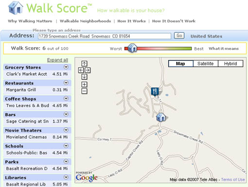
Amory Lovins' Rocky Mountain Institute: Not Exactly Transit Oriented!
Typically, when people think about how sustainable a neighborhood is, they probably think of neighborhoods with lots of organic stores, solar paneled roofs, small hybrid cars and a strong recycling/composting culture. And all of those ideas have their place, but I would argue that the most important is how walkable/bikable a neighborhood is. From Streetsblog, we discover a new website, Walkscore gives us a chance to calculate this aspect of different neighborhoods. While this is admittedly a crude measure and has some fairly obvious flaws, it is in many ways a good rough measure of how walkable a given location is compared to others.
Just pure density does not a walkable neighborhood make. It requires a healthy mix of residential, retail, services and office space. It means basically being able to accomplish pretty much any of your necessary daily trips by foot and not requiring an automobile.
For instance Amory Lovins' Rocky Mountain Institute gets a fairly low score since pretty much anyone that works there or wants to get lunch off campus HAS to drive there. However, most of Manhattan gets a 90+.
What is Walkscore? How Does it work?:
Walk Score helps people find walkable places to live. Walk Score calculates the walkability of an address by locating nearby stores, restaurants, schools, parks, etc. Check out how Walk Score doesn't work.
What does my score mean?Your Walk Score is a number between 0 and 100. The walkability of an address depends on how far you are comfortable walking—after all, everything is within walking distance if you have the time. Here are general guidelines for interpreting your score:
* 90 - 100 = Walkers' Paradise: Most errands can be accomplished on foot and many people get by without owning a car.
* 70 - 90 = Very Walkable: It's possible to get by without owning a car.
* 50 - 70 = Some Walkable Locations: Some stores and amenities are within walking distance, but many everyday trips still require a bike, public transportation, or car.
* 25 - 50 = Not Walkable: Only a few destinations are within easy walking range. For most errands, driving or public transportation is a must.
* 0 - 25 = Driving Only: Virtually no neighborhood destinations within walking range. You can walk from your house to your car!
It would be an interesting exercise to overlay these results with car ownership. If anyone can attempt this with census data on car ownership and commuting patterns, it would certainly be an interesting contribution to showing how walkable neighborhoods have reduced carbon footprint.
Walkscore is self-admittedly not perfect. It only uses an "as the crow flies" distance calculation which does not take into account how far something is to actually walk there on legal sidewalks. For instance, what if there is a retail strip half a mile away, but there is no direct pedestrian access to get to it because of how the streets are arranged, requiring a mile and a half trip instead. But in discussing that with some urban planning folks, this is still interesting information, because potentially the barriers and obstacles could be removed and pedestrian access could be prioritized over other rights of way. It also is not 100% up-to-date with all the potential destinations that contribute to the score. So if the nearby grocery store recently closed, that might not be included.
One key lesson from walkscore after taking a tour of various places that I have lived before is that while DENSITY is pretty important, ZONING is probably even more important. My childhood home in Staten Island, which was in residential only zoned area, received a score of 50, while similarly dense places I have lived in Ithaca received over 80. Also, ultra-dense places like Manhattan have fairly similar scores to mixed use areas of the outerboroughs and even small town centers.
A low-cost, pro-small business initiative that would vastly improve the walkability of any neighborhood, would be to ban residential-only zoning and specifically encourage mixed use zoning everywhere, even in the heart of the most suburban sub-divisions. Even if all plots at street intersections became eligible for commercial, retail or other uses, it would go a long way to producing more walkable communities.
Another lesson that I hope people have started to realize is that transportation is not just Vehicle Miles Traveled (VMT) and trying to figure out how to replace all of them with non-petroleum sources of energy. People in walkable communities make just as many, if not more, trips in a given week and they travel much shorter distances. Transportation policy should be about providing people with access to the goods, services, workplaces that they need, not encouraging land use patterns that place all of these as far from each other as possible and desperately trying to link them all together with roads and highways that are costly to build and maintain.
And not only are walkable communities more resilient to oil shocks and produce less carbon emissions, but they are healthier for our bodies too!
Personnel
Classic posts
Archives
- November 2008 (1)
- August 2008 (1)
- July 2008 (4)
- June 2008 (4)
- May 2008 (3)
- April 2008 (1)
- March 2008 (1)
- February 2008 (2)
- January 2008 (2)
- December 2007 (4)
- November 2007 (4)
- October 2007 (6)
The Oil Drum: New York City archives
- September 2007 (3)
- August 2007 (2)
- July 2007 (3)
- June 2007 (8)
- May 2007 (1)
- April 2007 (8)
- March 2007 (2)
- February 2007 (3)
- January 2007 (5)
- December 2006 (5)
- November 2006 (12)
- October 2006 (10)
- September 2006 (9)
- August 2006 (14)
- July 2006 (15)
- June 2006 (11)
- May 2006 (18)
- April 2006 (35)
- March 2006 (14)
- February 2006 (13)
- January 2006 (12)
- December 2005 (17)
- November 2005 (13)
- October 2005 (25)
- September 2005 (36)
License

This work is licensed under a Creative Commons Attribution-Share Alike 3.0 United States License.
The good news: My address in the West Nineties of Manhattan scores 95 -- I live in a walker's paradise! Hooray! Now the bad news: An increasing proportion of my neighbors drive. My block is choked with parked SUVs. The traffic now resembles midtown -- 30 years ago there were far fewer cars. The sad fact is that the more affluent the neighborhood gets, the more people drive. They are drawn to the richness of a pedestrian-oriented neighborhood. But they can't be stopped from bringing their cars here. This is a source of daily anger and torment to me.
its one reason I've been jobhunting in Manhattan.
I personally think New York is likely the best city to live in for the coming fuel crunch. Its already dense enough.
At least in Manhattan, the encouragement to have a car is tempered by the difficulty finding a parking place :)
its one reason I've been jobhunting in Manhattan.
I personally think New York is likely the best city to live in for the coming fuel crunch. Its already dense enough."
--The one problem with this is that when the economy gets a cold, NYC tends to get the flu,so to speak, because finance is really the foundation of the economy. When Wall ST. starts laying off, the RE market tanks, so on and so forth. About every 15 yrs the housing market here seems to collapse. the last time was in the early 90's, so we are basically due (and the layoffs are starting on WS) If you do move here, DON'T BUY. Rent something for the time being and I guarantee they will be giving stuff away within a couple years. There is a ton of building going on right into the teeth of this thing . perfect storm.
Matt
"My block is choked with parked SUVs. The traffic now resembles midtown -- 30 years ago there were far fewer cars. The sad fact is that the more affluent the neighborhood gets, the more people drive. They are drawn to the richness of a pedestrian-oriented neighborhood. But they can't be stopped from bringing their cars here. This is a source of daily anger and torment to me."
--Yes, I think this shows the limits to the model. I have lived in NYC for the last 10 years and do not consider it particularly ped-friendly. A lot of this is cultural which I think is why it doesn't show up in the model. There is just an acceptance here of domination of the streets by cars. Cars tend to be very non-deferential to peds crossing streets, bikes etc. the police take a very pro-car approach. It would be unheard of for a cop to ticket a cab for harrassing a biker ,even if they were in one of the intermitant bike lanes or for charging a ped in a crosswalk.AS far as walking goes, the city is ped friendly until you have to cross against turning traffic which is usually every few blocks.
Matt
Thanks for showing this!
I checked our house, and the walk score was 26, which is not walkable. I live in a suburb of Atlanta, not New York.
The reason we bought our house here is because it is on the edge of the University where my husband works. He walks to work every day, and my children walked when they took classes there. Many of our neighbors work on campus, and walk to work.
There is a bus stop on campus, so our house is walking distance of a bus stop. (This is rare in the Atlanta suburbs.) This was another reason we moved here. The map doesn't have that information.
There are other things the campus has, including eating places, concerts, a large library, and a book store, but the map doesn't include these. My impression is that it is looking only at commercial establishments.
I think the idea of the walkablilty score is a good one. My example shows that there are a few things that get left out. If you are looking at the neighborhood, you will probably want to combine a real-life look around with what the map tells you.
This program definitely has limitations and you identified a big gap - institutions. Obviously the typical college campus was designed around walking being the primary mode of transportation with everything from food to entertainment to visiting co-workers and friends very nearby or within close reach.
But just to play devil's advocate, for many institutions, you have to be a "member" of a community to have access to many of the offerings of an institution, which is where much of the Town v. Gown tension arises. This may not apply everywhere, but you get the point.
And now that you mention it, I wouldn't be surprised if America's reaction to peak oil would be to retreat into closed off or semi-exclusive institutional or religious/ethnic/class/trade communities.
Am I not a citizen, but a consumer? That's really how my Walk Score is geared. My result is quite funny, because I live in a small town (pop. 2,000) on the shore of a rather large lake. It didn't get that there are three Coffee Shop possibilities in my little town, and flagged a coffee shop across the lake (about 12.5 actual miles as the crow flies) with a real journey of 45 minutes by car! It missed the fact that we have a rather nice county park on the shoreline in town and that we have a public beach right at the end of my street. Bookstore? Does anybody go to a bookstore anymore? I suppose I would browse once in a while, but Amazon is my rural bookstore. Walk Score found one across the lake again. My local in-town hardware store wasn't listed and neither was my local pharmacy. Movie theater? Laughable. Fitness center? There's trails across my road which lead up to the National Forest. Why should I pay to sit on a friggin' machine as a consumer of health/lifestyle?
But my life is much more than shopping. Where' my nearest bus stop? How far am I from the Post Office?
it's not very accurate either. it placed a point for a store in lenexa Kansas only a few blocks from my house in olathe smack dab inside my subdivision.
Mine is about 80. I live in midtown Houston, 2 blocks from light rail (which I take to work). Large grocery store next block over. As far as living in a mostly unwalkable city, this is about as good as it gets. I could conceivably get by without a car altogether (my girlfriend and I share a single car.)
Personally I think zoning should be disposed of altogether. If you want to talk about market-based solutions... dumping zoning allows density to increase very quickly in neighborhoods, in a de-facto mixed use manner, where people want to live, while still keeping prices realistic. Houston has no zoning; as a result, neighborhoods very quickly respond to demand by building townhomes, condos, etc.
15. But that's because this is a rural farming community. It's a 1/2 mile to my mailbox. :) I think this little game is somewhat deceiving, if entertaining, because it assumes that one must go to a grocery store for food, commute to a job and so forth, most of which is not applicable to me. It also appears to arbitrarily decide that "pack 'em in like sardines" is a desirable way of life. But, I suppose some folks like that sort of thing, or are trapped in it ( if that's the case, you have my sympathy ). I'll pass thanks. I have no intention of changing my location to satisfy some "walk score". :) I can ride a horse & buggy if needed for long distances (over 10 miles).
This tool is really aimed at urban/suburban/town dwellers, not rural farming communities (especially if you are a farmer).
Hi Glenn,
Great idea ... in fact was just getting a comment ready for Stoneleighs Roundup about how 'inflation beating' things were in my neighbourhood when I took a break and looked in here.
Anyway I live in a small city of 60,0000 on a 1/4 acre lot and, if I follow the criteria correctly, would rate a 90. The only thing that is beyond walking distance for me is a major lumber and building supply store. Actually I think we would rate higher if you counted how far I have to go for vegetables, which is the back garden in summer and the freezer in winter.
Previously owned 9 acres but feel more secure here without the need to own transport and with just enough land, properly worked, to produce basic needs.
Many urban and suburban have the idea that security resides in large acreages when they have never grown so much as a carrot ... actually with the carrot fly problem, that has increased so radically here, that can be a real feat. Maybe change that to 'never have grown so much as a bean sprout'. One can starve just as easily in the country as in the city and I would think that the 30's spoke to that. ( on another flat note one should remember that the country (or Exurb?) is further from city soup kitchen than even the suburbs).
Lots of scope implicit in your topic, so will surely look in again to see further chat. If you don't mind I will post a site dedicated to things about providing for oneself and others: http://www.wtdwtshtf.com/
I live in the boondocks and was going to say much the same thing. The thing I find interesting is that the headings are things for which I, basically, have no interest. Heck, I not only don't go to movies but we stopped getting broadcast TV years ago.
Here is what I would include on the list:
How much of your food is grown locally or by yourself?
Why do you have to go to the grocery store so often? Don't you keep food on hand?
How much of your own power do you produce?
How much of your water do you produce?
How much of you heat and cooling do you produce?
To me, these are far more important than whether you can walk to a restaurant.
As an aside, our mailbox is a 30 mile round trip but we only go for the mail a couple of times a week and then do other errands at the same time.
Todd
I imagine this was driven by recent demographics, which indicate that more people live in urban areas now than in rural. So from that perspective it makes sense. It may indeed help those who want or need to live "close in" to have a better life, and I don't have a quibble with that. I lived in some very large cities myself once upon a time, and they do have their attractions. I miss the variety of cuisine available in Seattle for example. But; my attitude now is that although a major city is a fun place to visit occasionally, I wouldn't want to live there anymore, if only because of the crowding and traffic. I like the freedom to step outside my woodshop and take a leak or bag a deer that happens to be walking by, without worrying about nosy neighbors. :) I like the freedom to dig a pond or fill one in, or cut a tree down without getting permission from some self-important "community committee". If I want to put up a building or tear one down, I just do it.
My POV may sound selfish to some, and perhaps it is. But until you've experienced this level of seclusion it's impossible to know how liberating it is. Not many folks that live this kind of life have a full time shrink. :) As Hank Jr. says: "Country folks can survive" :)
No man is an island
Rural density varies considerably, and you are apparently on the low end for even rural density if you can kill a deer (in season ?) with no one noticing.
Transportation is a greater issue for rural locations far from the nearest town, doctor, dentist, feed store & supply, school, etc.
Before my grandfather bought a farm close to town, he went to town every other Friday "if the weather was good", except around harvest time. Post-Peak Oil, travel in rural areas will be constrained, as will support services.
Exurban commuters, a significant % of the rural population in some areas, will likely disappear.
Alan
Alan, you're correct on all counts, but a little planning goes a long ways. And, yes in season :) I'll be looking for dove soon, yum! My little patch is inhabited by all kinds of critters besides deer. Fox, beaver, 'coon, 'possum, dillers, and so on, including the occsasional cottonmouth (had one in the garage this summer!). All the usual field&forest life found in NE MS. A regular zoo. :)
Btw, I love NO and the Gulf coast generally. We try to get down there every year or 2. Have some good friends down that way. I finally found a source for Abita beer up here. :)
Hey Gene,
I do all those things above except shooting the deer that wander up the small river (or is it large creek) by my house, and like I said I live in a small city of 60,000. I don't need a personal FF transportation device and the city gives me a library, winter recreation centre, art galleries (of a sort), a Playhouse, a railway and bus station for inter city travel, also many many social groups from a dalia growers association to a Hells angles club.
I've Lived in the boondocks and enjoyed it but wouldn't want to spend my life there, and anyway I can walk there in about 20 minutes:)
If we as a 'civilization' hadn't done time as much as we have in cars maybe we could have taken that time and those resources to make our living arrangements livable. This is where I think Glenn's article leads. Be nice if it took a swing past population control as well too ...
That sort of personal freedom of choice in lifestyles is one of the great things that makes this country as great as it is. And in large part what made that possible is personal cheap transportation - oil in other words. If, or when, that choice disappears we will have lost one of the things worth living for. I really hope we can find a way to avoid that loss.
So you guys with the grand ideas for electric, pocket size cold fusion generators, or just plain magic; and the talent to make them a reality; better get to work. No more time off. ;)
No problem living without oil all we have to do is go back to a preindustrial population, something we should have done by choice rather than have it forced upon us by circumstance. The problem lies in having an anchor that keeps one from being part of that solution.
There are many types of anchors and a walkable community can be one as can a quiet woodland dell. Personally I am betting on the small town a good garden and a tradeable skill or two.
Best wishes and keep those flints dry.;)
All of these things that you have mentioned are important when Peak Oil's effects become palpable. But remember (not just talking to you but to others) that the Walk Score is NOT a "Peak Oil Safety Indicator". It admits right up front that it's a service to help homebuyers find a community that is highly walkable. Thus, it is catering to people who want to live in a city and want to walk around to various large stores. It's not catering to people who necessarily want to be self-sufficient in a crisis situation.
Todd,
I think the Walkscore web site was not intended for people who are asking the questions you are asking. And if you already know the answers to the questions you ask, then Walkscore is irrelevant.
And ironically, I think that for those who do not know or care to ask the questions you ask, the site is equally irrelevant. Who cares about walking when there are two cars in the garage?
Maybe there's a third group who just want to confirm how "Safe" or "Screwed" they are. A quantitative scale by which to compare themselves with the rest of the country, like a credit rating or salary survey.
Here we go again with "Those who are ignorant of history are doomed...".
Although zoning currently is a major impediment to sustainable mixed use development, zoning laws were instituted for very good reasons which are still existent.
After a 24 hour noisy metal stamping factory moves next door to your house, your opinions on zoning would likely changes, since even earplugs would not keep out the low-frequency vibrations from stamping. Similarly, most people would not like having a junkyard, porn store, toxic waste dump, shooting range, etc. move in next door and destroy property values and quality of life.
The most magnificent examples of urban development on Earth were all results of some form of zoning. For example, Paris the "city of light", followed the design standards of Baron Haussman. Most people would argue that Paris has a more beautiful and functional design than Houston (with its' absence of zoning).
http://en.wikipedia.org/wiki/Baron_Haussmann
OTOH, non-conforming uses are key to adding character to a neighborhood.
The French Quarter had, until ~5 years ago, a sheet metal fabrication company taking up most of a city block (est 1880s from memory). Forklifts with sheets of metal amidst locals & drunk tourists. Oyster shucking & wholesaling still goes on in the FQ.
When I lived in the Faubourg Marigny, I had to contend with the air pollution of a wholesale bakery :-)
And Commander's Palace restaurant is a non-conforming use, as are most corner grocery stores.
Less zoning could be very good,
Alan
Watch it Alan you're getting close to promoting anarchy, maybe NO is ready for that but is the rest of the land ?:)
BTW have you ever lived close to a factory farm chicken ranch? I have and the first I knew of it was when I woke one night to the most ungodly stench but when I looked outside could smell only the lilacs in bloom, confused me no end till I found out, that being good neighbours, the farm would clean out once a week at night, rather than in the day, and by the time I woke the smell outside was gone leaving only the pong inside. I started to think we were haunted... it was an older farmhouse on the edge of city zoning.
I agree less zoning could be very good and if we were very good then no zoning at all.
I expect a lot of the issue is scale. Localization requires mixing up a variety of uses. But it one thing to have a dozen chickens next door, a whole other thing to have 10 thousand!
Paris, the City of Light, had its design standards imposed by fiat by Baron Haussman. It was forcibly reconfigured. How many people were displaced? I love Paris, I'm currently thinking of moving there permanently, but the actions that lead to its grand avenues could never (and should not) be recreated.
If you reread, I never said Houston was beautiful. What I said is the absence of zoning allows a city to rapidly reconfigure itself to meet changing demands (ie. higher urban density) while keeping property values affordable because there are not artificial constraints on the market.
woolie,
you're right about zoning and the unwalkability of much of Houston. I assume you live near Fiesta, probably in a condo in those condo's built a block north of Sear's Tire and Battery store. And although the neighborhood is very walkable for you, its seriously impaired for your girfriend after dark.
I don't like that program. The information seems very inaccurate for Galveston. I live a quarter mile from the beach and 1/4th to 1/2 of a mile from two schools which have basket ball courts and a track, yet we have no parks. I live within 1/2 a mile of of six restaurants, the same on the program. I'm within 1/2 of a mile of a medical school, a nursing school, health clinics and have great public transit with a block to the bus and 10 blocks to the streetcar and can get to shopping easily, with 3 book stores, several coffee shops and several bait stores in range plus the bicycling is great. Many of my neighbors don't own cars.
The program really ought to at least put live bait as a transportation requirement, it will even things up with Manhattan,Boston,Philadelpia and Washington D.C. which also need to be moved along with New Orleans and Galveston. (sarcanol alert, you humorless so-and soes).
I think the walkablity and bikeability may be a function of the age of neighborhood as much as anything else. Almost all the buidings were built between 1870 and 1915 around this part of Galveston, and those types of neighborhoods were built with more easily accessable small busineses in most cities. Looking out the windows by my desk I can also see a former neighborhood grocery and a former tavern, and neither has any parking except on the street. I'm within 1/2 a mile of the port, and many of the people that live around here were employed as longshoremen at the port when it was built. Bob Ebersole
The program really ought to at least put live bait as a transportation requirement
But bait tastes *SO* much better once cooked with a roux and rice !
Best Hopes for Cajun Cuisine,
Alan with cooked bait within 1/4 mile
Alan,
It sure does. I often buy bait shrimp and cook 'em myself. They cost $2.00 a pound, about 1/3rd the cost of "table" shrimp and are almost alwaysmore fresh They are often smaller than the table shrimp, but since there's only 2 or 3 most often when I'm cooking, the size doesn't matter.
Now you've talked me into it again! I'm off to the grocery and the bait store, shrimp etoufe' here I come!
1/2 lb of shrimp per person
1 stick butter
2 tbs. flour
bunch of green onions
fresh garlic
1 tablespoon tomato paste
Tony Chacere's creole seasoning
white rice
clean shrimp. Thats 1/2 lb cleaned, or about 3/4ths lb. with heads
put rice on to boil
melt butter, use two sticks if more than about 3-4 people
whisk in flour, cook for about 5 minutes, or until flour just starts to get a very light brown, then thin with water to the thickness of cream gravy
throw in garlic minced very small, or mashed in a garlic press, Tony Chachere's, about 1 or 2 tablespoons of tomato paste, green onions chopped and saute while doing this for about 2-3 minutes keep it stirred
throw in shrimp, cook no more than 3 minutes. When they change to solid white they are done, remove from heat, serve over rice
goes great with a crusty french bread and a salad
The thing to remember is don't overcook the shrimp, they get small and tough quick, and keep the etoufe' stirred so it doesn't stick. Crawfish is even better, but don't use tomato paste for crawfish etoufe' but be sure to use the fat. Always preboil crawfish before cleaning them.
Also, if its more than the next day until garbage day, freeze shrim or crawfish heads until trash pick-up
Bob Ebersole
Yes, near the midtown Fiesta, but not in those condos, but a nice, restored 1920s duplex on Eagle St at Caroline. You have to keep your eyes open after dark, but I've lived in this neighborhood (in different parts) for about 5 years now and only once had any instance of crime (car window broken.)
Galveston is wonderful, and extremely walkable, given it was completely platted out before cars really existed. If they reopen the Interurban railway, I'd visit frequently. But it's such a long and unpleasant drive to get there now...
woolie,
one of our city councilman, Dianna Puccetti, is trying to open commuter rail between Houston and Galveston. It won't be on the old Interurban Right Of Way, much of that has bben eaten up over the years, the Gulf Freeway is on a part of the Houston land, but there is other railroad ROW.
I've got her coming to Alan Drake's workshop at the ASPO Conference Oct. 17-29th at the Hilton America's in Houston. I hope you are planning to attend, it should be great.
There idea is to get electrified commuter rail to Clear Lake, then hook up with Houston Light Rail. Our federal government is paralised, but we really need to start on mitigation now, so I'm working on my local end. Communities with plans in place are going to get federal funding first when congress starts pannicing. Bob Ebersole
Yes, I hope to attend (trying to scrape together the cash.)
I like this as a way to find things when out of town. If you are on business or on vacation it quickly lists all the things around you in categories. Even to find stuff in your own community that you may not have known about.
My score is 68 for a small town of <4000. I hope WalkScore keeps improving, it is an excellent idea. I should say I live two blocks from a train depot, but alas, cars are still king and passenger rail is only a gleaming possibility here in 30 year old metro transit plans which gather dust.
To my surprise, my Manhattan Beach address in CA scored an "unwalkable" 48. Yet most of what I need day to day is in downtown Manhattan Beach, .82 mile away.
What is missing is how pleasant that .82 mile is to walk or to bike ride. In many parts of Southern Cal I would not want to walk half that distance. But here, it's great.
Yup - that's absolutely true. And part of this exercise is to show how there are many other factors than pure distance that influence the "walkability" of an area. But it's a good starting point.
Agreed. I looked up an old address on Long Island and was astonished at how well it scored. I never realized: The distances were not far. It was just so astonishingly miserable to walk anywhere! Pure automobile land! Even to walk a few blocks was traumatic.
My score was 71, in Mill Valley CA (Bay Area)--
It missed several opportunities, a major public school, and Whole Foods Market a few blocks away--
I posted this link a month or two ago in a DrumBeat. Before, the site would often be clogged and give no result.
It is also faulty in not including transit access. And some other details as well.
None the less, a useful tool.
I got 77 in the Lower Garden District of New Orleans. A recent TODer visit can confirm how walkable it is (except for movie theaters).
Best Hopes,
Alan
http://reddit.com/info/2iulh/comments
if you are so inclined... :)
The data used to calculate the score is quite poor. In my test, they listed a closed, small, drugstore while ignoring the three large chain stores within a half mile. They also listed a small mom and pop grocery while ignoring the supermarket one block further.
In fact I specifically bought my house where I did because of the ability to walk to all the important local merchants. It is also within walking distance of the LIRR which I took to work for many years.
One of the reasons I stay put is that having close by shopping and other services means that there is less need to rely on driving as one gets older. I see plenty of my fellow retirees walking to and from the same stores. Several of the nearby assisted living facilities that have sprung up allow for walking or have a bus to take people in a group. This is all very efficient.
I'm in Great Neck, NY which is the first town past the NYC border on Long Island. I'd call it pseudo-suburbs. The local government likes "mature" suburbs instead. They are now doing planning as to what to do next. Mature suburbs don't have the same growth patterns and influx of young people as new areas.
What I notice, in addition to the crow fies issues is that it does not know which roads have sidewalks. I walk to the store from time to time but not with the kids because part of the route puts pedestrians out in the middle of the road.
Chris
And the quality of the walking experience :-)
Best Hopes for Beautiful Urban Landscapes,
Alan
If you come from the UK this is one of the things that really surprises you about the US.
I have visited twice, once in Long Island, the second time in North Carolina.
Both times there were malls within easy walking distance of where I was staying, but no sidewalks.
So either you walk through flower beds and hedges, or you walk down the road with cars nearly hitting you - both very unpleasant ways to get about.
Even in low density suburbs in the UK there is almost always a pavement (sidewalk) on at least one side of the road, normally both.
To an outsider the US appears designed for exclusive car use.
One of the issues with public sidewalks in the USA is that they are extremely costly and time-consuming for the adjacent property owner. You typically get assessed when they are put in; you typically have to maintain them; you have to keep them clear of ice and snow in winter; and you may get stiffed with a huge lawsuit if some moron trips over a slab vertically misaligned by as little as 4mm, or if you unexpectedly can't be home on a certain day to clear the ice and snow and someone slips on it.
Generally speaking, there may be assessments for certain kinds of repairs to the road and the utilities. However, adjacent property owners are normally not responsible for plowing the snow or clearing the ice, and are not normally sued over snow, ice, or defects in the road surface. The road benefits everyone and day-to-day operation is (mostly) conducted and paid for accordingly. Municipal or perhaps county crews clear the snow and ice, and they or contractors make the repairs. This is not so for sidewalks.
All told, the system is strongly biased against sidewalks, and makes them a highly undesirable burden. Rarely will anyone in their right mind vote to put them in, if they have any say in the matter.
Is this different in the UK?
In the UK, the pavement is normally adopted along with the road, and is maintained by the local authority (municipality), who would also be liable for lawsuits. (I believe that compensation from a UK lawsuit would probably be a lot lower than a US lawsuit).
Why a road should be considered a public good, but a sidewalk not, rather puzzles me.
The Pedestrian
It is an interesting site. I got a 93 in midtown Toronto.
Many of the comments show how rough an estimate this is and others indicate that while a rough estimate, it is still valuable. Of course, it doesn't factor in everything, that is what eyes and ears are for. I picked my current address in St Louis Park, and previous addresses in Minneapolis. Now one of the areas which came up as highly walkable used to be a very walkable neighborhood, but that changed as drugs and crime moved in. I used to walk 3 blocks to the grocery store or take the bus to a store and carry groceries home on the bus. Not much fun, but it was doable. I also visited the neighborhood where I grew up last night, and remembered the corner stores which had been replaced with industrial buildings
A useful, starter tool. Score of 66 for my neighborhood in SW Portland, Oregon, though with very good mass transit access (and improving) our experience of it is much higher than that. (When a high-quality coffee shop moved in recently things picked up dramatically around here...;->) Neither a neighborhood pocket park nor our own city park is listed. My wife could use local transit, and does sometimes, but we both drive to work.
Four thoughts:
1) following on capslock's point upthread, the scoring relies heavily on access to commercial goods and services; with more effort people could gauge their access to other public spaces/institutions than parks and libraries (post office? police dept.? community center? senior center? day care?). Also no listing of churches/places of worship, easily available data which could be plugged in.
2) There's no substitute for local knowledge, which is inherently specific and local, difficult to aggregate in a tool like this.
3) In a way this is in part a measure of social capital. People would themselves figure out how close they are to friends, neighbors and family, which would figure centrally in any assessment of their quality of life (and ability to deal with PO stresses).
4) most TOD'ers would expect exurbia to score lowest. But what is the social class dimension in all this? Here's my rough first guess as to how walkability would generally scale by class (income level), from most to least walkable:
urban wealthy (townhouses, condos)
settled middle in older urban areas
urban poor
suburban poor (typically in older suburban areas)
older suburban middle
wealthiest top tier
exurban newer middle class
Relaxing zoning standards somewhat could really open up opportunities to redress local imbalances in access to services and goods.
Not to be nitpicky, but you might wish to add a category or 3. Rural/boondocks - wealthy, middle, and low. Includes farmers, ranchers, etc. Keep in mind that most of this category of people also have various forms of animal transportation, so walking, bikes, etc. is not their only option.
Before cheap transportation, rich families had to have their servants nearby, and before fast transportation if a owner or manager needed to visit their office or plant, it was the same. Who wants to ride very far when its raining and snowing or 100 degrees and high humidity? Even the most fancy carriage is miserable for a long ride, so rich people had to live close to their factory or office. Only cheap, quick transportation enabled the economic segregation that is represented in massive, demographicly similar suburbs.
Peak oil is going to change where people live a lot.
Bob Ebersole
Interesting topic.
In many urban areas, non-motorized travelers have to often fight through a maze to get from point A to point B. I would suggest people map out the artificial corridors and barriers that surround themselves.
Here is a maze that I have to escape from, the star is home base, all the white lines are freeways, impassable industrial areas, and the occasional river or lake. The only passages are through the gates shown:

In a car it is much more straightforward.
well to be honest that only applies right now. in many ideas of the future the traffic will be mush less allowing you to maybe cut across some roads etc to cut the distance.
Not in my neighborhood !
An "intricate" maze of 28' wide (parking both sides) one way streets :-)
Anyone recognize a theme in a set of street names ?
Best Hopes for Beautiful walkable neighborhoods,
Alan
Perhaps people shouldn't be living below sea-level :)
You mean that we should evacuate older areas of Boston ?
Or just get the US Army to keep it's 1928 and 1968 commitments to New Orleans ?
St. Charles Avenue is about MSL and it rises slightly from there.
Alan
http://www.timesonline.co.uk/tol/news/uk/science/article2195538.ece
From the article above, it is better to drive than to walk for the environment.
Absolutely true !
You die a dozen years sooner (and may have less sex & fewer children), thereby reducing your environmental load significantly !
Best Hopes for Obesity,
Alan
I suppose the point is that eating beef and exercising is worse than being a vegetarian and driving. It says diesel trains are twice as polluting as cars too. Go figure!
To repost what I said in a previous Drum Beat...
The argument is bogus for a lot of reasons. Here's one: A pedestrian walking at a slow stroll burns calories at the same rate as the body of a car driver (2 kcal/kg/hr). In some cases it takes more calories for a person to operate a vehicle than to walk, depending on the vehicle and the speed of the walker. Since most walking trips are completed in less time than most driving trips, on that basis alone walking trips take less energy.
There's more discussion on this comment thread:
http://gristmill.grist.org/story/2006/8/15/13311/7678
I entered my 100 000 town in the Czech Republic. Surprisingly, it found the place on map, but then rated the walkability as "Worst". Which is nonsense, as most towns and cities in the Czech Republic are eminently walkable.
Thylacine why do you call yourself Thylacine?
I bought a mountain bike just recently to cycle 5km of dirt tracks to the nearest roadhouse. I have to push it uphill on the way back…old thylacine country.
Because you cannot be a "consumer" in Czech town.
As a previous comment said, the program checks for Bars, restaurents,supermarkets, Bookstore, Gym etc, If it cannot find any then you get a low score. It is geared for the US mostly and it is more to get the concept across than an actual comparison.
On a whim I typed Chembur Station, Mumbai India, and was surprised that it came up with a map at all, But the score was 0. Meanwhile you can do "everything" if you lived within a mile of Chembur station, from buying flowers, vegetables, stocks, gold,pirated bollywood dvd's to possibly Uranium - See BARC is the Atomic power agency. Anu -Shakti is Atomic energy, not Anus - hakti.
http://walkscore.com/get-score.php?street=chembur+station+mumbai+india&g...
Well, for me it said the nearest hardware store was "McCormick Paints". Great if you need paint or a paintbrush. Not of much use if you need anything else.
The nearest library was "Ernst & Young". WTF?? That's an accounting firm.
In a way I am more interested in what is bikable. I have a Whole Foods about 3 miles away, and I have a new pannier for my bike.
Whole Foods - is that like Healthy Forests and Clear Skies?
No, it is a grocery store (chain, actually) that specializes in organic and health foods. It can get pricey, but if you stick to simple stuff like produce, you can get out without spending a fortune.
There are 2 other supermarkets a similar distance away. The produce at Whole Foods is much better though..
For me, Whole Foods is a nice, one-mile walk around the Inner Harbor. A reasonable number of bike racks and not finding High Fructose Corn Syrup in nearly every item more than offsets the cost.
Ours also has bike racks - and good ones at that. Plus it is right next to the WO&D trail - a major bike trail in our area.
The sooner the US realises that it must adopt a strong planning system based on sustainability the better. In the UK we have town centres first policies, where a sequential test is required for out of town shopping centres to proove that they cannot be incorperated within or on the fringe of existing centres, as whole units or split into smaller units. Locally important shopping parades are protected from conversion to other uses. Residential development is limited to areas that are served by public transport. New development that is not served is generally only allowed as an urban extension with developers providing bus services, schools, libraries, employment space, shops, recreation space, etc. and the developments must be of a density capable of sustaining those services. The UK is also now requring in many places that 10% of projected energy consumption of new major developments is provided on-site with renewable energy, the high cost of this incentivises energy efficiency measures to reduce the obligation.
But the US has no federal policy guidance regarding planning and each state chooses its own way, many with no planning whatsoever. This must change if the US wants to create sustainable communities that are peak oil proof. Developers hate it, so you need ballsy radical uncorrupt politicians to make it happen. The US is unfortunately bereft of such a thing and democracy virtually defunct given the infiltration by corporations via the intense, unscrutinised lobbying and funding of politics in the US.
"Nobody needs to go anywhere else. We are all, if we only knew it, already there." (Aldous Huxley "Island" 1962, p38)
However, everything has its downside. Maybe this plethora of requirements - i.e. obstacles - is one reason why the UK has an incredible shortage of decent affordable housing. (Similar to California and New York City.) So these positives only work for you if you have won the economic lottery in a big way.
Manhatten my eye, check out this little doll of a city....
http://walkscore.com/get-score.php?street=2nd+and+Main+Street+Louisville...
Sometimes we don't know how good we have it.....:-)
RC
Southern isn't a place, it's a state of mind...:-)
PLAYING AND THINKING WITH WALKSCORE
An hour and a half later and I am still playing with this "Walkscore" thing! This is more addictive than blogging! :-)
A few things I have learned....
(a) a very small move in distance can make a huge difference in walkscore.
Some may see that as not fair, but it is exactly that way if you try to use walking/bicycling to get around. Miles become of great importance, especially in bad weather.
(b) Once more, the social aspects loom very large. By which I mean CRIME. There are some areas that are great to walk, but simply cannot be considered safe. The issue of gangs looms larger even in small and mid size towns than many assume. On the other side of the coin, a young person out walking is immediately suspect, and will be stopped by police in many areas.
(c) The more I play with the "walkability" thing, the more fascinated and astounded I am that local electric cars have not been a success SOMEWHERE on some scale! Let me stay to this by way of example for a second, because again, it astounds me....
I have a friend I work with who has (as do I) shall we say a "well used" car. Let me stress, VERY well used. It has been paid off for years, and every percent of depreciation is gone out of it except the scrap price (well, as is mine (blush)
So how does she travel? She simply rents a car on the rare occasions that she needs to go more than 5 or 10 miles. It works very well, because when you think about it, many folks do not go on long trips all that often per year.
But what this means is that even a modest electric car of some 30 to 50 mile range would be more than she needs, in fact, more than she currently demands! She is not in condition to walk, and I shudder to think of her walking in thunderstorms or sub zero weather, and the recent run of 12 plus days at over 90 degrees (often over 95 degrees) would simply not be walkable in a real way for most people.
If the issue is reduction of liquid fuel consumption in a big way for MOST people, a path between the gasoline car and walking is needed, and will be the one accepted by most.
O.K., let's play....
I have a modern electric (I actually don't, but let's say I do....)
http://www.seriouswheels.com/cars/top-2004-Volvo-3CC-Concept.htm
Volvo gives the range as 180 miles (astounding number that is) but let's assume they are exagerating (everybody does), and go with 100 flat and save wear on the batteries...
You walk the walkable town when able (good weather or if healthy enough) but slightly longer distances than walking can do or in bad conditions, you use the electric.
Need to go out of town? You rent a car for that. Need to haul something? You rent a truck. Thus the great dream of the anti gasoline engine crowd, you need own no privately owned gasoline car, your consumption of gasoline virtually collapses, and the strain is pulled off of the liquid fuel supply. Will it save you money? Well, no....
Unless gasoline goes to at least $8.00 per gallon, let's admit, there is very little advantage to walking or to the electric. If you live within walking distance of most of what you need, you will use very little gasoline anyway even if you drive, except recreational driving, which, by the way, is the only reason you would walk....recreation, and at least a bit of health benefit (if it's not a 100 degree day!) Darn, I may have just remembered why that electric car idea didn't catch on!) :-)
RC
There are several GEMs in New Orleans. Three in my neighborhood before Katrina, at least one now.
They are easy to park :-)
Best Hopes for NEVs,
Alan
http://www.gemcar.com
This is why I think electric bikes will work. Range is between 20 and 35 miles (depending on speed and terrain). This covers most errands and most commutes. If you have 5 miles to go, it will take 20 minutes. This is less time than it takes a car since you do not have to fool with parking.
In most states there's no DMV, no property tax and no insurance to fool with.
The biggest hassle, or benefit depending on how you view it, is that you need to take back-roads and bike-paths to avoid higher speed traffic. Which also means you have to really know your area and use maps. In lousy weather you gear up or take the bus.
Bikes work... unless patronizing the mall and chain restaurants is your thing.
I'm in a somewhat similar situation to you and your friend. We've always driven old, paid-for clunkers until they are almost dead, and rented when we needed to go on trips, or the car was in the shop, or (rarely) when we needed larger hauling capacity. If you are trying to live frugally, that really is the way to do.
We live in a small town that is fairly walkable. I only live two miles from work, and I COULD walk to work if I really had to. The walk would require walking part of the way along a main street without a sidewalk, so I'd rather not as long as gas is only around $3/gal and there are still a few maniacs on the road driving SUVs inattentively. I also try to consolidate all of my shopping on Saturday mornings. Because I am bringing home a whole week's groceries, walking is not a very practical option. If I had to just go downtown to buy one item at the hardware store, for example, I could (and sometimes do) walk.
My daily commutes and weekly shopping trips could indeed all be done with an NEV. And, in fact, as soon as one of our cars has just about outlived its usefulness, we do plan to replace it with an NEV.
I've heard Frankfort is really nice? What you think? Never been but might pass through sometime.
Matt
Restaurants, coffee shops, bars, movie theaters, schools, bookstores, fitness, clothing & music stores - I have no desire to go to any of those. Guess I'm not a very good consumer. (well, occasionally to a music store that sells guitar strings).
The site gave me a walkability of 12.
However, immediately in front of my house is a bus stop which runs directly to the middle of my closest town, currently runs every hour, and takes 10 minutes each way. For that matter, the same bus will take me to the beach if I stay on it 15 minutes. I average about 500 miles on my car each year.
But there's a much bigger "however". Post-peak a few years, I see NO reason that any of the stores in my local town will have anything inside them. Indeed, no reason for there to BE a town there. The location of many US towns seems to be based on nothing more than random aggregation of population which has been logical for placement of distribution nodes. Why in the world whould I expect the town to still be there in the future, much less its infrastructure of movie theaters, coffee shops, and grocery stores stocked with just-in-time produce shipments from far-off lands?
What do we all think we'll be walking to?
This is funny...my downtown Evanston Illinois address gets a score of 100 -- two better than my old Upper West Side address in NYC! My old address was definitely more walkable, but we are getting along just fine in Evanston without a car -- we were "real" New Yorkers, and we let our drivers licenses expire, and we're too lazy to get new ones.
One general point I'd like to make is that the absolute number one, most important single attribute of a walkable neighborhood is to have a supermarket. If you have a supermarket that is very close, it drastically cuts down on car trips.
The other point, and something that might be worth a more in-depth analysis, is, how many neighborhoods are truly walkable? By which I define -- could you get along without a car? I didn't know about downtown Evanston until we got here-- and it probably helps, although does not guarantee walkability, that it is home to a major university (Northwestern). I also lived near campus at Berkeley with no need for a car. Are there other areas around the country that can be lived in without a car?
Oak Brook, Illinois (corp. HQ for McDonalds) only scores a 12, and I ashamedly agree with the generalized rating, although we use our village trail system daily to walk the fox terrier; we rarely bump into anyone on the trails there is no town Centrum, we have no walkable destination besides the library > arrgh. So when we do finally move will anyone wanting to live in this town ante up for our 2.5kw PV and solar thermal? Don't tell the wife, she's all about resale...
My house received a score of 0. I agree completely with that score: if I wanted to purchase the things I need on a daily basis. Instead, it doesn't account for the fact that my workshop is better equipped than a hardware store, my farm is a grocery store, and my home is pretty much a library.
I would like to see a chart that asks people (over the age of 25) where they live, and where they grew up. What's the sense in having schools, libraries and stores in a tight grouping if nobody wants to stay there in the first place? Many places I have lived didn't deserve to have the libraries and schools they had, because the places were populated with idiot consumers anyway. Now most of those places have been 'improved' with even more strip malls and TV stadium churches. Apparently, war is good for Gods and fast food nations.
Well, where I live in Jersey City one can certainly live without a car very easily, and many do. We have a car, but use it mostly to leave the city and go hiking on weekens andand vacations. The car is parked 4 or 5 blocks away, and sometimes I have to go and turn it over so the battery doesn't die.
One of the things we use it for is to visit my daughter who lives on a commune in W Va. The walkability index for the commune is probably as low as ours is high. But if things really get rough, where would I rather be? They grow a lot of their own vegetables, raise several different kinds of animals, have a pond to swim in, abut a national forest and are close to a state forest. So you can't get anywhere from there without a car, but there's the potential to survive without going anywhere.
O dear. This thread reminds me that we are seriously doomed. I have to go away now, for a long time. Byby.
I live 15mins walk from central london, have three underground railway that each take 5mins to get into central london, am walking distance to about 15bus services, half of which operate 24hrs/7 days a week, and am walking distance to Europe's busiest mainline rail junction. Yet, my neighbourhood, apparently is mediocre in terms of walkability. There are also about five schools within walking distance. The search engine only picked up about a quarter of the businesses in the area. It takes me 10mins by underground to get to Europe's busiest shoopping high Street (Oxford Street) for goodness sake.
The initial comments about density are misplaced. If where I lived wasn't dense, it could not support mass transit, and local businesses/services don't thrive where there aren't people.
"Nobody needs to go anywhere else. We are all, if we only knew it, already there." (Aldous Huxley "Island" 1962, p38)
Transit is not covered. "5 & 10 minutes by tube" is great for you but that is not walking (and London fares are high).
They miss some businesses in the USA, but apparently more in the EU.
Hopefully improved in future revisions.
Alan
Clarendon, a suburb of Washingon DC scores an 85. Probably about right, you don't need a car here. We could use some more medical and we lost our hardware store recently (converted to restaurant)so it's not ideal. The streets are still too car-oriented in some places, making walking less comfortable but the score doesn't consider that.
Mixed-use proximity is the main consideration of this ranking it seems and that is a good basic measure.
Last month my Fed Hill apartment got an 83, but now it is up to 91. I wonder what changed ...
How walkable is my neighborhood? A half a mile to the nearest neighbor. 2 miles to the highway. 7 more to town.
Another 15 to visit Todd. I could probably do it in a day.
Rat,
You know you are always welcome - even with an ICE. But, I'll tell you, my wife and used to hike a lot when we were in our late 20's and early 30's and I wouldn't want to hike from your place to mine in one day. Remember, you gain 1,500' in elevation in the last three miles to our place when you are pooped out.
Keep on trucking!
Todd
Actually, my late neighbor was an old timer. Way back when, he had a date with the gal he married. Her folks had a ranch on the back side of Farley Peak, across the valley. His car wouldn't start, and they had no phone, so he just set out on foot. She told me she felt really badly that she gave him a ration for being late, before hearing his story.
Somewhere way back in his family, one of them worked at Union Lumber in Ft. Bragg. He would walk the 18 miles or so over to the coast on Monday. Friday night he would walk home with two boards on his back... and so their house was built.
2 days after I heard that story, I was at the baseball field, and one of the kids on my LL team said,"Coach, I'll pay you to drive me to town." (About 3 blocks, folks.) Told him we had parked and walked. Grrrr.
Fifty feet to the garden. Two hundred feet to the pond with the fish. Half a mile to the elk herd. Two hundred and fifty yards to a deers side. A hundred feet to the root cellar. Quarter mile to the irrigation ditch siphon. A mile to a milk cow. Two miles to a chicken coop. Three miles to a gas station and two hundred feet to a bioplant.
Two miles from a grease recycler to pick up waste oil. A thousand feet to a thousand pinon trees.
A thousand miles to Willitts
Six feet from Heaven
Bill on the Hill
Hey, Buddy, long time no see. How's things?
Rat
Smokin'
Hows by you?
Bill on the Hill
Working too much; 14 months to retirement :>)
You gonna show up on SI again?
A couple of comments:
1) As several people have noted, the database is inaccurate & incomplete. I live one block from a park, it has the nearest one being 2.36 miles.
2) I live about 3/4 miles from the center of my small town, and almost all of the services it picked up were located there. Because they were 3/4 miles away, I only got a walkability score of 34. However, if we are talking about walkability, isn't there something to be said for having a lot of services clustered near each other? If I walk downtown, I am likely to go to the public library and two or three different shops. It does matter that the walking distance between all of them is minimal. If they were all located a shorter distance from my home, but all in different directions from each other, it might actually require MORE walking to get to all of them.
This is not so much of an issue in a dense urban CBD, but it does become one in smaller communities.
3)Most of the streets in my small town don't have sidewalks, but the speed limits and traffic density are low so that is OK. I can still safely walk to downtown. If I had to get there via a busy, dangerous thoroughfare, it wouldn't matter how close downtown was. Walkability is at least as much about how safe it is to get from point A to point B on foot as it is about the distance between point A and point B.
The website won't even recognize our address, nor the older addresses surrounding it. On the map of our area, it missed significant schools and groceries and post offices. This development is about 10-15 years old and more stores and residences are still being built here.... I used to think it was very car dependent because our preferred stores are further away. But now that I think about it, in a pinch we could probably manage here without a car.
But not post carbon era. Where are all those stores going to get [cheap] supplies shipped from? And if the economy crashes, most income to buy from those stores will dry up anyway. So the stores might not exist.
A post peak walkability map would address where to get supplies that were more locally and sustainably produced. For instance, if you live near a tourist center that replicates old fashioned methods of doing things, you'd at least have the nearby knowledge how to do it. For example colonial Williamsburg or something similar. Also, if you lived near a navigable river, then you might have access to tradable goods from further away.
Happiness is... a peak-nik in his victory garden!
This Walkscore posting generated excellent comments. It misses some very important destinations like public transit stops, places of worship, day care centers, etc. But critics should remember that Walkscore is a brand new, rough-draft FREE tool that some guys threw together. Moreover, the developers were very clear about its shortcomings and their willingness to incorporate suggested improvements. And the name itself reminds us of its focus - it's not "BikeScore" or "TransitScore" or "FarmScore" or "SelfSufficiencyScore". I challenge anyone to name a better tool for estimating the walkability of those communities in which the vast majority of Americans live - people who, incidentally, purchase most of life's necessities and are more than nominally involved socially.
And what a great free tool it is! I live in a village of 8,535 people, have served on the village board, and have closely followed development and zoning issues, including the drafting and approval of the village's Comprehensive Plan and its more-than-one-inch-thick Zoning Ordinance. These documents cost the village hundreds of thousands of dollars.
There is a good deal of happy talk in these documents - especially the Comprehensive Plan - about objectives like "reducing absolute reliance on the automobile", building more walkable neighborhoods, establishing bicycling networks, etc. The Zoning Ordinance has lots of details on street widths, lot sizes, setbacks, minimum parking requirements, and historic character in the downtown.
But Walkscore - with all of its current shortcomings and raw edges - is already a much more valuable tool for community planning than the type of formal documents my municipality uses at present. Why? Because Walkscore absolutely nails the most important factor in walkable communities - PROXIMITY OF DESTINATIONS. Yes, factors like public safety are essential too, but without proximity all the public safety in the world won't get people to walk two and three miles to the grocery store.
My fervent hope is that Walkscore developers will evolve it into a full-featured commercial product, for sale to community planners. It will inject much needed REALISM into the development process.
Meanwhile those of us who like our isolation need to remember that the ACT OF PARKING destroys, undermines, and prevents walkability everywhere else, for everyone else.
>> It is absurd to call driving a personal choice. <<
Not when America has eviscerated most of her historic downtowns to accommodate the motorist. Not when the private automobile remains a top contributor to global warming. Not when our nation, having burned through most of her own once-abundant reserves of cheap oil in the historic blink of an eye, has invaded and occupied other lands for more. Check slides 15 and 62 here:
http://t8web.lanl.gov/people/rajan/energy_RG_06.pdf
Peace begins with cobwebs on gas pump handles.
Hans Noeldner
"Civilization is the presence of enlightened self-restraint"
My last word on the whole damn planet. Screw it. Lock and Load. And the first targets are the blood sucking Lawyers. Last man standing wins.
I laughed out loud when I saw the example you used in the Walkscore: The Rocky Mountain Institute is so easy to make fun of. Snowmass does in fact have transit service to Aspen through the Roaring Fork Transit Authority. It's a couple of miles to the nearest bus stop from RMI, but that's a bikeable distance in the summer. I believe there might be transit service to Glenwood Springs from Snowmass, also.
RFTA (Roaring Fork Transit Authority) has bus service from Aspen all the way downstream to Rifle. (67 miles)
RMI is in a subdivision with not much extra land except for straight up around it. The only walkable area is on the highway down to Snowmass Conoco or across Jimmy Buffett's old place and Glenn Fryes cabin. If u ain't a parrothead I would suggest using the two lane along the river.
Watch out for cars as the richies will run over you. Locals will wave tho....
True country folk don't need to go to town much tho. Its the transplants that need it. Movie fix and such.
Mountain types get by with a fiddle and a friend.
Garden helps as well.
Bill on the Hill
I always buy a house with the main criteria being walkability and distance to work. I have lived in Denver, Eugene, OR, and now Lincoln, NE. The interesting aspect is that I always end up in the old part of town. Any new development is not walkable, or amenable to mass transit and never will be. Something must be done about land development practices. If one used GIS to contour the walkability (perhaps an enhanced walkability coefficient that incorporates comments posted here) in any city, the coefficient would decrease away from the older parts of town with small business districts and streets with sidewalks that are on a grid instead of a maze. Bike paths follow creeks and rivers and are typically not commuter or transportation routes for shoppers. Changes can be forced by the real estate consumer and ideas can be presented by engineers and land use planners as well as regulators and those on commissions.
D
Derek Ryter, PG, Ph.D.
Professional Geologist